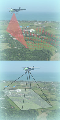
Airborne Scanner
The Airborne Scanner is used for measuring large extensive or long areas. The hardware
for Airborne Scanning contains a variety of components. The system we use was developed by the
Ingenieur-Gesellschaft für Interfaces, IGI. The main equipment is the the LMS-Q560 scanner
of the Riegl company and secondary the modificated
Hasselblad camera DigiCAM-H39. All components will be installed on a single platform in an airplane or helicopter
before starting the measuring. As a first result you get point clouds and aerial photographs. Out of these you
can derive more results.
Examples of our work can be seen via the links on the right side or by taking
a closer look at our projects.
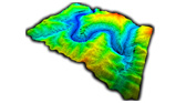
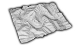
- Point data
- georeferenced point cloud - as-built documentation - generating of site plans and contour plans - digital terrain models (DTM) - digital surface models (DSM) - Image data
- orthoviews - mosaic pattern - generating site plans - Geology
- survey of large areas - geological analysis of rock layers - 3D-modelling and photo-realistic texturing of rock formations - reservoir modelling with the help of digital data - Archaeology
- exploration of large excavation sites - discovery of potential excavation sites - Industry
- planning of routes for road construction, rail traffic and energy industry - urban development and planning such as 3D city models - 3D-models - determination of areas and volumes - Disaster management
- documentation of natural disasters such as avalanches, landslides and floodings - as-built documentation and oberservation of endangered territories like overhangs - analysing of floods - Visualisation
- 3D presentation (internet, pdf) - photo-realistic illustration of real objects in 3D - animations