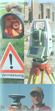
Surveying
Within the field of surveying we can offer a wide variety of different
services for you. This is due to the usage of modern and newest equipments.
Examples of our work can be seen via the links on the right side or by taking
a closer look at our projects.
- Site plan
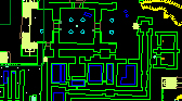
- survey of the topographical stock and presentation in scaled plans - Ground plans and sections
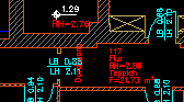
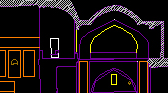
- generating of longitudinal sections and cross sections as well as ground plans for planing and documentation purposes - preparing views, e.g. facade maps - creating of floor plans at multi-storey buildings - Indoor surveys of buildings
- providing ground plans, sections and floor maps - registration of the living-space, usable floor space and rented area - documentation of pipelines and the course of cables - Stakeouts
- rough and fine stakeouts of main points or axis of buildings, traverses - Surveys for Facility Management Systems
- registering and mapping of facility management elements in ground and floor plans - establishing of room books with relevant informations for each room - Registration of areas and volumes
- creating of digital terrain models (DTM) - registration of areas (gross and net areas) - registration of floor space - determination of areas to be cleaned like ground-, glas- or facade-surfaces - GPS - Satellite surveying
- Control- and deformation surveys
- continious surveys at objects with especially strict regulations for the position and height sturdiness - surveys of subsidence for the monitoring of the stability of old buildings, bridges etc.