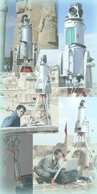
Laser Scanner
For surveying large objects we use the terrestrial RIEGL laserscanner with
a mounted calibrated camera. The objects are completely scanned
from different positions and will be merged into one 3D point cloud. This point cloud
can then be used to produce different results.
Examples of our work can be seen via the links on the right side or by taking
a closer look at our projects.
- Point cloud
- generating of site plans - 3D-models - views and sections - digital terrain models (DTM) - orthophotos, projections and developing drawings - Geology
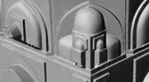
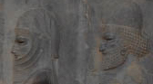
- 3D-modelling and photo-realistic texturing of rock formations - geological analysis of rock layers - reservoir modelling with the help of digital data - Archaeology
- fast and efficient documentation of a excavation site and its progress - precise documentation of the finds locations - Industry
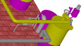
- as-built documentation of industrial plants - 3-dimensional CAD plans such as documentation of piping - 3D-models - determination of areas and volumes - Restoration
- documentation of damages at existing structures - as-built documentation as a basis for planning restorations - generating of site plans, ground plans & sections, views (single stone elevation), 3D-modelling with photo-realistic texturing, orthophotos - Disaster management
- documentation of natural disasters such as avalanches, landslides and floodings - as-built documentation and oberservation of imperilled territories may be at hang over - analysing of floods - Visualisation
- 3D presentation (internet, pdf) - photo-realistic illustration of real objects in 3D - animations  example (2.3 MB)