Photogrammetry
With the help of photogrammetry it is possible to fulfil different tasks
and to measure objects on the basis of photos within millimeter accuracy.
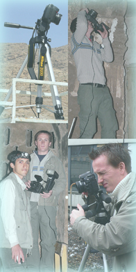
For these services we use a high resolution
digital reflex camera with a range of calibrated lenses.
Examples of our work can be seen via the links on the right side or by taking
a closer look at our projects.
- Sections and views
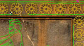
- generating of cross and longitudinal sections for planing and documentation purposes - preparation of facade maps, e.g. for historical analysis of buildings - Documentation of damages
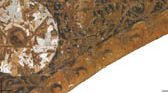
- accurate evaluation and documentation such as damages of facades by creating detailed plans, which could be the base for facade repairs and restoration works - Orthophotos
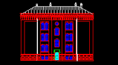
- creating of deskewed photos, scaled photographic images - used for developing and updating topographical and city maps - creating of complete image-maps by a mosaic of several orthophotos - Developing drawings and projections
- scaled rectification of curved surfaces (archs, towers, etc.) into the plane - projection of multiple curved surfaces e.g. projection of a cupola to a cylinder - Analysis of aerial photos
- developing of topographical and city maps - creating of deskewed images of the earth's surface